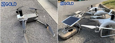
Indeed to collects accurate data-quickly and safely?
Then take a look at our GPS PPK kit for DJI drones.Drones have become a vital piece of kit for surveyors.
Deploying unmanned aircraft on job sites yields fast and accurate data capture-gathered safely and efficiently.
Our kit is suitable for the following models:
Phantom 4
Phantom 4 Advance
Phantom 4 Pro
Phantom 4 Pro 2.0
Mavic 2 pro
Mavic 2 Zoom
As a professional upgrade tool, our kit can make drones perform better in mapping operations.The GOLD geomatics PPK product suite includes hardware kits for aerial mapping with most cameras, whether on drones or manned aircraft.Developed by geospatial professionals for geospatial professionals. Traditionally, aerial surveys require many GCPs (Ground Control Points) on the entire site to achieve reasonable absolute geographic location accuracy. With the GOLD PPK system, there is a simple and effective solution that can save hours or days on site and get better results.
Compared with other kits on the market,the GOLD ppk kit has advantages in hardware and software.
Hardware
High performance, low power consumption, microcontroller.Capable to achieve data sampling rate up to 10Hz.
High-precision GNSS, OEM board.Having the highest level of quality assurance measurement data.
Battery bulit-in .Makesure constantaly use approches 12 hours.
Lightweight. The GOLD PPK kit only weighs 60 grams.
Software
Supporting multiple parallel receiving channels, which can track and observe all GNSS satellite signals to the maximum extent, including China's Beidou signal, American GPS signal, Russian GLONASS signal, and SBAS signal.
High POS( positioning and orientation system)accuracy, the largest can meet the topographic survey of 1:500.
PPK operating mode does not need communication, only needs to collect static state, the drone has a larger operating radius, and it is not easy to lose satellite signals.
Specific parameters:
Models | F2 | |
Mechanical | Size | 56.4 * 45.3 * 14.6 mm |
Weight | 56g | |
Operating T | -25 ~+60 | |
GNSS | Signals | GPS L1/L2, GLONASS L1/L2 BeiDou B1/B2, Galileo E1, E5 SBAS |
Tracking channels | 184 | |
| Interface | Event ,TFcard |
Led | Power,logging,SV,Event | |
Positioning | H | 5mm + 1ppm |
V | 10mm + 2ppm | |
| Update rate | 5Hz |
Electrical | Input voltage | 5V,8V-35V |
Antenna Dc | 5V | |
Average Current consumption | 25mA | |
Data | storage | 16GB |
Data format | Rinex | |
Connetivity | Antenna | Mcx |


Please feel free to contact us to get more details!
